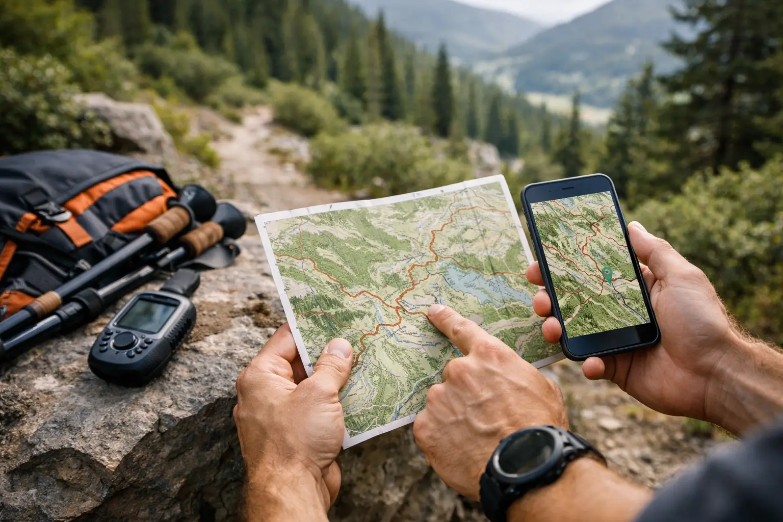
You do not notice weak course prep at the start line. You notice it at mile 27, when the course splits on a dark ridge, your phone has no signal, and the race PDF you skimmed two weeks ago is useless. That is where offline trail race maps stop being a nice extra and start becoming race equipment.
For trail runners, a map is not just a line on a screen. It is pacing context, terrain warning, climb timing, aid station spacing, and cutoff awareness. If it only works when you have service, it is incomplete. Most races happen in the exact places where connectivity gets unreliable fast, especially in mountain terrain, deep forest, canyons, and exposed backcountry sections. If your race planning depends on live data, you are building confidence on a weak foundation.
Why offline trail race maps matter in actual racing
Organized trail races create a false sense of security. Markings exist. Volunteers exist. Other runners are nearby. But none of that removes the need to know the course for yourself. Course markings get missed. Packs spread out. Weather changes visibility. Fatigue wrecks judgment. When that happens, having the route available offline can keep a small mistake from turning into a costly one.
The bigger benefit shows up before race day. Good offline mapping lets you study the course without interruption and carry that same version into the race. You are not switching tools or hoping a cached screen loads correctly. You are using the same route, same elevation profile, same waypoints, and same aid station references from planning through execution.
That matters because trail racing is rarely decided by one big mistake. It is usually decided by a series of small errors - climbing too hard because you underestimated grade, skipping calories because you misjudged the next aid station, or losing minutes on a junction because you were not ready for it. Offline access reduces those errors because the course stays visible when conditions get messy.
What good offline trail race maps should include
A downloadable route is the minimum. Serious race prep needs more than that.
First, the map has to match the race course cleanly. That sounds obvious, but many runners still rely on low-detail race website images, old GPX files, or community uploads that miss updates, reroutes, or exact aid station placement. A race map is only useful if it reflects the course you are actually running.
Second, elevation has to be readable and actionable. Total gain alone tells you almost nothing. You need to know where the long climbs begin, how steep they get, where runnable sections return, and how descents stack into already-fatigued legs. If your offline map gives you the route but not the terrain logic, it only solves half the problem.
Third, aid stations and cutoffs should live on the course map, not in a separate document you may or may not remember to save. Race decisions happen around these points. You want them fixed to the route so you can judge effort, fueling, bottle carry, and split expectations in one view.
Fourth, your offline map should work with the devices you actually race with. For some runners that means a phone in airplane mode. For others it means a GPS watch loaded with the course file. The best setup is the one that survives battery limits, bad weather, and tired hands.
Offline maps are not just for navigation
There is a common mistake in race prep: treating maps as emergency backup only. That undersells their value.
The strongest use of offline trail race maps is planning. You study where the early bottlenecks happen, where the race opens up, where the major climbs sit, and where the course stops being runnable in a meaningful way. That changes how you train and how you pace.
A 50K with one brutal climb at mile 8 asks for a different opening strategy than a 50K with rolling vertical the whole way. A 100 miler with long gaps between aid stations changes hydration planning more than shoe choice ever will. A course with technical descents late in the race may justify conservative uphill pacing earlier, even if the total gain looks manageable on paper.
Offline access makes this kind of prep more reliable because you can keep reviewing the course anywhere - on flights, in mountain towns, at packet pickup, in a parked car near the start, or in a tent the night before the race. No signal required. No broken page loads. No race-morning scramble.
The limits of basic GPX files
A GPX file is useful, but it is not the whole answer.
A plain route file gives you geometry. It does not automatically give you race intelligence. It may not tell you which checkpoint matters, where an aid station sits relative to a major climb, or how the race divides into manageable segments. It definitely does not tell you what parts of the course deserve caution when fatigue sets in.
This is where many runners still do too much manual work. They download one file, screenshot the website map, copy cutoff times into notes, then try to combine all of it in their head. That process works if you have unlimited time and high tolerance for error. Most athletes would rather spend that energy on training.
A stronger setup organizes the route, elevation, waypoints, and race logistics into one offline-ready view. TrailSight is built around exactly that idea: know the trail before you run it, with course detail that holds up when race-day conditions do not.
How to use offline trail race maps the right way
Start with the whole course, then break it into race-relevant sections. Do not memorize every turn. Focus on decision points. Where does the first long climb start? Which aid stations are far enough apart to affect bottle carry? Where do the steep descents land relative to your expected fatigue? Where are the cutoffs tight enough to matter if your day goes sideways?
Then match the map to your pacing plan. Not perfect pace. Real pace. Trail runners get into trouble when they build plans around ideal conditions and smooth execution. A useful map helps you pace around terrain transitions and logistics, not just distance markers.
It also helps to review the course from both ends. Study the opening miles so you do not burn matches early. Then study the closing third even more closely. Late-race navigation and terrain awareness matter more when fatigue is high, daylight is fading, and simple choices get harder.
Before race day, test your offline setup. Load the route onto your primary device. Confirm it opens without service. If you are using a watch, verify the course transferred correctly. If you are using a phone, make sure battery management is realistic for your expected finish time. Offline capability only helps if it actually works under race conditions.
Trade-offs runners should think about
Not every race demands the same level of map detail. A well-marked local half marathon on familiar terrain is different from a mountainous ultra with remote sections and long aid station gaps. The deeper the course complexity, the more valuable offline planning becomes.
There is also a trade-off between simplicity and detail. Too little information leaves you guessing. Too much can clutter your focus. The right map setup gives you what affects performance and decision-making: route fidelity, elevation context, aid station placement, and race-critical waypoints.
Device choice matters too. Watches are efficient and reliable for on-course navigation, but their screen size limits broader planning. Phones are better for studying terrain and aid station spacing, but they depend on battery discipline. Many runners do best using both - phone for preparation, watch for race execution.
The real advantage is confidence you can use
Confidence in trail racing should come from specifics, not optimism. You do not need to know every rock and switchback. You do need to know where the race can punish bad assumptions.
Offline trail race maps give you that edge. They reduce guesswork before the gun goes off and keep the course accessible after service disappears. More importantly, they turn race information into something usable - where to stay patient, where to eat, where to push, and where to pay attention.
Run enough trail races and you learn this fast: uncertainty costs energy. Good prep gives it back. Carry a course map that still works when the mountain does not care about your signal, and you will make better decisions when they count.