A bad course preview usually looks fine until mile 40. The profile seemed manageable, the aid stations looked evenly spaced, and the route line felt simple enough. Then race day hits, the climb is steeper than expected, the descent takes more out of your quads than planned, and your nutrition timing starts to drift. That is exactly where a 3d trail race map earns its keep.
For trail runners, a map is not just a route trace. It is a planning tool. The value of a 3D view is not the visual effect. It is terrain clarity. When you can see how the course rises, folds, traverses, and drops across actual ground, you make better calls before the gun goes off. You pace more accurately, pack more intelligently, and stop treating the race website like a complete briefing when it usually is not.
Why a 3D trail race map matters
A standard flat map tells you where the course goes. A 3D trail race map helps tell you what the course will feel like. That difference matters because trail racing is rarely decided by mileage alone. It is decided by climbing density, runnable sections, technical transitions, and how fatigue stacks across terrain.
A 12-mile climb does not race like a 12-mile climb if the grade keeps changing. A descent into an aid station can look friendly on a profile, then turn out to be rocky, awkward, and slow. A ridge section might appear short on paper but expose you to wind, sun, or pace loss if it comes late in the day. Seeing the course in three dimensions gives context that a stripped-down elevation graph often hides.
This is especially useful for ultras and mountain races, where pacing mistakes early on compound fast. If you misread one major climb, you do not just lose a few minutes. You can miss fueling windows, arrive at aid stations behind schedule, and start chasing cutoffs instead of racing your plan.
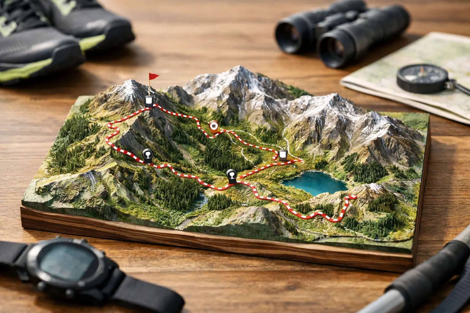
What a good 3D trail race map should show
Not every 3D map is useful. Some are little more than a route draped over terrain. That can look impressive without answering the questions runners actually care about.
The first thing to check is whether the terrain view makes vertical gain understandable at race scale. You should be able to identify where the course really bites - long grinders, abrupt walls, rolling false flats, and descents that are too steep to recover on. If the map smooths all of that into a clean shape, it is not doing enough.
It should also help you read the order of effort. That means seeing how major climbs and descents are distributed across the day, not just how many feet of gain the race totals. Two races with the same elevation gain can race completely differently depending on when those efforts hit and how technical the terrain becomes between them.
Aid stations and waypoints matter too. A useful 3D map does not isolate terrain from race logistics. It helps you see where support points sit relative to climbs, creek crossings, ridgelines, and cutoff pressure. An aid station at the bottom of a climb asks different things from your nutrition and bottle strategy than one perched after a long exposed ascent.
Finally, the map should be practical beyond the screen. If you cannot export the route, study segments, or pair what you see with pacing and distance data, the 3D view becomes entertainment instead of preparation.
How runners actually use a 3D trail race map
The best use of a 3D trail race map starts before race week. It helps shape training. If the course shows repeated steep climbs with short descents, your long runs should reflect that pattern. If the race has extended runnable downhill late, you need eccentric durability, not just climbing fitness. Terrain is training information.
Closer to race day, the map becomes a pacing tool. You can break the course into effort-based sections instead of relying on average pace targets that make no sense in the mountains. Flat-road thinking fails quickly on trail. A 3D course view helps runners identify where they can move efficiently, where they need to stay controlled, and where time losses are normal rather than alarming.
It also sharpens aid station planning. Serious runners do not just ask how far apart aid stations are. They ask what terrain sits between them, how long each segment should take, whether there is reliable water, and how much climbing falls inside each stretch. If one segment includes a major climb in heat, you may leave with extra fluid and calories. If another is a fast descent into a crew point, you may travel lighter and move quicker.
This is where a structured platform helps more than a generic mapping tool. TrailSight, for example, organizes course intelligence around the way racers actually prepare - terrain, aid stations, pacing, cutoffs, and watch-ready files in one workflow instead of scattered tabs and screenshots.
Where 3D maps help most - and where they do not
A 3D trail race map is most valuable when the course has complexity that a flat view hides. Mountain races, point-to-point ultras, and events with repeated climbs, technical descents, or remote aid station gaps all benefit. The more consequences there are for getting terrain wrong, the more useful the 3D view becomes.
It is also a major advantage for runners traveling to races they cannot preview in person. If you are flying in from another region, you may not have a chance to recon key sections. A 3D map will not replace local knowledge, but it can narrow the gap. You can at least understand where the race is likely to turn tactical or punishing.
That said, a 3D map is not a crystal ball. It does not fully capture surface condition, weather, footing quality, or how a trail runs after eight hours on your legs. A descent that looks moderate may still be loose and punishing. A contour that appears smooth can hide roots, rocks, or mud. Terrain visualization improves decision-making, but it should sit alongside GPX review, elevation analysis, segment planning, and race-specific notes.
There is also a trade-off between visual clarity and detail. Some maps exaggerate terrain so much they distort scale. Others are technically accurate but too cluttered to be useful. The best maps strike a middle ground. They give enough realism to understand the course while staying clean enough for fast interpretation.
How to evaluate a 3D trail race map before trusting it
Start with one question: does this help you make race decisions? If the answer is no, it is decoration.
Look at the biggest climbs first. Can you tell where they start, how sustained they are, and what comes immediately after? Then check descents. Are they gradual enough to run hard, or steep enough to force restraint? After that, study the spacing of aid stations and key waypoints. A map becomes far more useful when terrain and support logistics sit in the same frame.
Next, compare the 3D view with the elevation profile. If they tell different stories, slow down and figure out why. Sometimes the profile reveals sharper gradients than the map suggests. Sometimes the 3D view exposes terrain stacking that the profile flattens. Using both together usually gives the clearest picture.
Then think operationally. Can you export the GPX? Can you review offline? Can you align course sections with your watch, fueling plan, and cutoff targets? A good map should feed your race system, not live apart from it.
The real payoff: fewer surprises, better execution
No one needs fewer unknowns more than a trail runner standing at the base of a climb they misunderstood. That is the practical value of a 3D trail race map. It reduces false assumptions.
When you know where the course tightens up, where the long exposed section begins, where a descent might trash your legs, and where aid station spacing gets awkward, you race with more control. You stop reacting late. You start planning earlier.
That does not make trail racing easier. It makes your decisions cleaner. You still have to climb, manage your effort, fuel properly, and deal with whatever the day gives you. But if you can read the course before race day, you are already solving problems before they cost you time.
Know the trail before you run it, and the map stops being a graphic. It becomes part of your race plan.